| |
 |
 |
 |
| |
UltraCamXp
reduces the number of flight lines saves
time, and lowers cost, without sacrificing
radiometric performance
The UltraCamL
provides the same high geometric accuracy,
broad dynamic range, matching and stereo
capabilities, and full metric capabilities,
as the large format cameras. The image data
are suitable for DSM (digital surface model)
production, aerotriangulation, ortho mapping
and 3D technical vector mapping.
The collection rate and geometric
accuracy of the UltraCamL allow users to
produce urban maps with minimal occlusions
and Digital Elevation Models (DEMs) with
no spikes or holes. Automated image analysis
is also made possible by the superior dynamic
range.
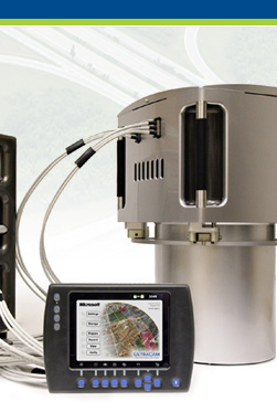
The UltraCamL makes
use of the same data flow concept introduced
with the UltraCamX. The low-cost, exchangeable
solid-state storage devices hold approximately
1 TB each, the equivalent of around 3,600
images. When one unit is filled, it can
simply be replaced with another during flight,
allowing unlimited image collection in the
air.
|
|
 |
|
 |
|
|
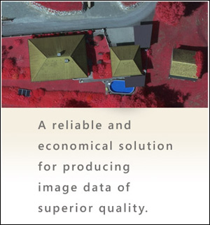
The Microsoft UltraCamL photogrammetric medium format
digital aerial camera provides a reliable and economical
solution for producing image data of superior quality.
Taking advantage of the large-format camera concept
that has proven most successful with the UltraCamX and
UltraCamXp, the UltraCamL now offers the same geometric
accuracy and dynamic range in the medium format market.
The collection rate and geometric accuracy of the UCXp
allows users to produce urban maps with minimal occlusions,
and Digital Elevation Models (DEMs) with no spikes or
holes, and to produce high-quality large-scale ortho-photos.
Automated image analysis is also made possible by the
superior dynamic range of the UCXp.
 |
| |
Without sacrificing image quality, the UltraCamL can
be used on smaller airplanes, and thus operated at lower
cost. Smaller mapping companies now have an affordable
option for offering a digital platform and expanding
their aerial services. The UltraCamL is also ideal for
larger mapping firms who need to cost-effectively fly
small projects or collect digital data in conjunction
with lidar or other data.

F E A T U R E S
 Top
Top
- Highest quality medium format available (64 megapixels
in pan format; 9,735 across track, 6,588 along track)
means superior price/performance ratio
- 1:1.83 pan-to-color ratio delivers brilliant true-color
and color-infrared (CIR) image quality with unmatched
radiometric range
- Short frame interval allows multi-ray photogrammetry
even for large-scale mapping at low altitude and high
aircraft speed; forward overlaps of 80% are achieved
at a 10 cm pixel size at 105 knots
- High level of detail with no blur due to Forward
Motion Compensation (FMC) using Time Delayed Integration
(TDI)
- Pixel size on the ground (GSD) at flying height
of 486 m is 5 cm (10 cm GSD at 972 m altitude)
- Removable storage units provide two benefits: the
length of missions is limited only by the constraints
of the aircraft; ground time is minimized
- Maximum use of legacy environments; supports ALL
standard gyro-stabilized camera mounts (PAV-30, Z/I-TAS,
GSM3000) and most common GPS/IMU system
- Utilizes only a sensor head with integrated sensor
and computing sub-systems, integrated computing sub-system
and integrated solid-state devices (storage sub-system)
for maximum reliability; no additional computing or
storage units are required
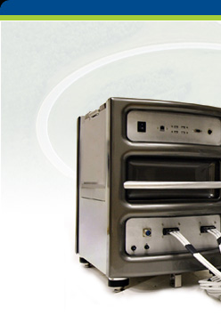
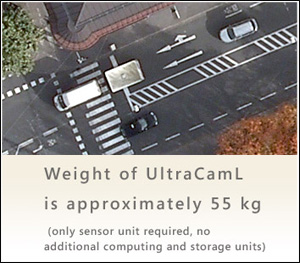
- Weight of UltraCamL sensor head is approximately
55 kg
C O N F I G U R A T I O N
S
Top
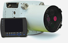
Sensor Sub-system (integrated in the sensor head)
- Simultaneously collects Pan, RGB and NIR
- Panchromatic image size is 9,735 x 6,588 pixels;
color and NIR image size is 5,320 x 3,600 pixels
- State-of-the-art 7.2 micron CCD technology allows
64 megapixels in pan image
Computing Sub-system (integrated in the sensor head)
- Processes raw images on board in real time, to compute
quick views and histograms
Data Sub-system (integrated in the sensor head)
- In-flight storage capacity is limited only by number
of solid-state storage devices on board, given space
and weight constraints of aircraft
- Approximately 6,600 uncompressed images per DXp
unit (~4.2 TB) can be stored
- Approximately 3,600 uncompressed images per device
(~1 TB) can be stored
Operational Specifications
- At 70% and 20% overlap, with 20 cm GSD and flying
at 140 knots, the data collection period is approximately
7 hours per SSD unit
- Post-processing can begin in the air and be completed
on the ground with a laptop or group of PCs
- Image geometric accuracy is approximately +/- 2
µm
- Time between frame collections is 2.5 seconds
- Weight of UltraCamL is approximately 55 kg (only
sensor unit required, no additional computing and
storage units)
|
|