|
|
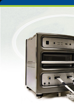
HARDWARE : UltraCam

Designed by Vexcel
Imaging, every component built by an industry
leading precision manufacturer, integrated by one
of the oldest names in photogrammetry; UltraCam
delivers the highest productivity
and radiometric quality in aerial imaging. Ultracam Xp offers 17320 pixels across
the flight strip, with 70mm wide angle lens, translates to
photo width of 742m at 500m AGL and image
resolution of 4.3cm. The amazing image quality and
contrast is a result of using the highest quality, latest 6um sensor
technology which, in the UltraCam, produce the
best grey scale values of any large format camera
in the industry. Naturally, UltraCam offers
simultaneous high-res panchromatic, individual
colour channels (R,G,B) and near infrared (NIR).
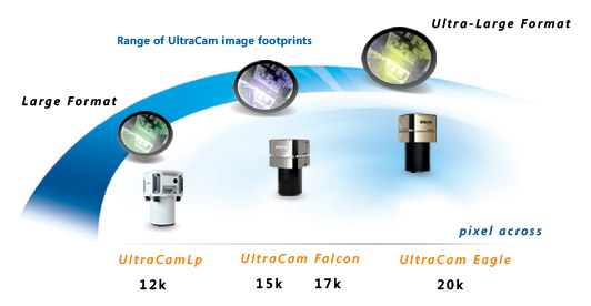
UltraCam technology
is offered in three solutions tailored
for the
matching business requirements:
-
 New!
New!
UltraCam OSPREY: best-in-class flight
collection efficienty, the UltraCam Osprey
is designed so that the full swath width
of the nadir cone (11,674 pixel) can be
used and wing image overlap is high enough
to generate oblique orthos as well as
textured DSMSs. The UltraCam Osprey is the
ideal sensor system for projects such as
urban mapping and 3D city modeling.
-

UltraCam Eagle: building on the
award-winning design innovation of
UltraCam, the new Eagle is the ultimate
high resolution, large format sensor with
highest productivity and reliability in
aerial optical sensors.
-
UltraCam Falcon: new integrated
electronics, INS, storage, in a single
sensor head; high-resolution, supreme
accuracy, optimum productivity, low-high
altitude aerial photogrammetric sensor,
70mm or 100m focal length.
-

UCLp:
high-resolution / accuracy / radiometry and price
performance redefining the medium format camera
(@90MP)
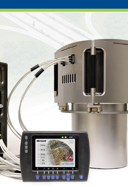
In flight
UltraCam provides real-time sensor monitoring,
feedback on exposure, image quality and
navigation. UltraCam provides a level of quality
assurance such that the flight controller can
assure a successful collection first time, every
time.
UltraCam has a
complete range of accessories to assemble a commercial off the
shelf aerial imaging solution from a single
supplier:
UltraCam accessories include: integrated inertial
navigation system and post-processing of IMU/GPS
data, flight. |
|

 |
|
|
SOFTWARE : UltraMap
Latest
Release! UltraMap 3.0
 UltraCam efficiency
in the air is matched by unrivaled productivity
and ease of use in office processing. UltraMap is designed for the production shop
intent on producing accurate, intelligent imagery
in the shortest time. The UltraMap suite produces
pan-sharpened colour-balanced imagery across a
whole block
with the minimum of fuss. Proprietary software
developed by Microsoft for Bing Maps is leveraged in UltraMap for tie point processing
and radiometric correction. UltraMap is
multi-threaded utilizing the cores available
within the CPUs on a network. UltraMap
Aero-Triangulation (AT) offers project management,
task monitoring, distributed processing, intuitive
and productive graphical interface while
maximizing the opportunity to automate the AT
processes. At its conclusion, UM-AT provides a
detailed set of text and graphical quality
assurance reports providing a complete assessment
of the block adjustment. UltraCam efficiency
in the air is matched by unrivaled productivity
and ease of use in office processing. UltraMap is designed for the production shop
intent on producing accurate, intelligent imagery
in the shortest time. The UltraMap suite produces
pan-sharpened colour-balanced imagery across a
whole block
with the minimum of fuss. Proprietary software
developed by Microsoft for Bing Maps is leveraged in UltraMap for tie point processing
and radiometric correction. UltraMap is
multi-threaded utilizing the cores available
within the CPUs on a network. UltraMap
Aero-Triangulation (AT) offers project management,
task monitoring, distributed processing, intuitive
and productive graphical interface while
maximizing the opportunity to automate the AT
processes. At its conclusion, UM-AT provides a
detailed set of text and graphical quality
assurance reports providing a complete assessment
of the block adjustment.
UltraMap
extends beyond AT to
ortho-mosiac production
including colour balancing and seam line
feathering. UltraMap GXL Aerial uses hardware
leveraged software for maximum performance
in ortho-rectification. GXL Aerial utilizes
the surprising power of Graphic Processor
Units (GPU) on typical NVIDIATM
graphic cards to distribute and phenomenally
accelerate processing times. The combination
of UltraMap AT and GXL maximize automation
possibilities, simplify the process and
accelerate the production from aircraft
to geometrically precise, radiometrically
stunning ortho-imagery.
|
| |
|
|
SERVICE : Support
programme
UltraCam is backed by a flexible in-field
support programme that let’s you choose the
level of support and maintenance suitable for your
experience and production needs. Cameras can be
re-calibrated at factory in Austria or USA, or in
the field with factory support. Spare parts are
available at multiple locations around the APAC
region for immediate response if necessary and
spare cameras are strategically located to ensure
no client is ever inconvenienced by the unlikely
event of a factory flaw or unforeseeable accident.
Innovative, inspired
and intelligent,
with the investment and attention of Microsoft,
UltraCam and UltraMap leverage hundreds of man
years of R&D in image collection, processing and
presentation to deliver a sophisticated and
efficient end-to-end geospatial information
production system.
|