| |
|
|
Microsoft Vexcel Aerial Mapping
Solutions
Deliver your geospatial information fast and
with stunning image quality. Stay competitive
and achieve amazing results for less with Vexcel
Imaging Aerial Mapping products that include the
UltraCamXp large format digital aerial camera,
UltraCamL medium format camera, and UltraMap Software.
|
|
| |
|


The new Microsoft UltraCamXp Wide Angle large
format digital aerial camera takes advantage of
the same superior camera concept and image quality
as the UltraCamXp but features a new proprietary,
digital, high-performance, high-resolution lens
system with a shorter focal length.
 more
more
|
|
| |
|
|
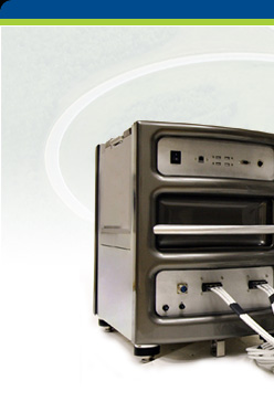
The Microsoft UltraCamXp large format digital
aerial camera meets operational challenges, providing
mapping customers with a reliable and economical
solution for producing image data of superior
quality.
more
|
|
| |
|
|

The Microsoft UltraCamL photogrammetric medium
format digital aerial camera provides a reliable
and economical solution for producing image data
of superior quality. Taking advantage of the large-format
camera concept that has proven most successful
with the UltraCamX and UltraCamXp, the UltraCamL
now offers the same geometric accuracy and dynamic
range in the medium format market.
more
|
|
| |
|
|

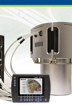
UltraMap provides a complete and integrated photogrammetric
workflow for UltraCam images. It consists of a
flexible and scalable distributed system for managing
and processing vast amounts of UltraCam data integrating
UltraCam-specific hardware such as the DX data
units, and the DKS docking station to support
field and office environments.
more
|
|
| |
|